Nostalgia and views – in and beside the Schynige Platte Railway


- 1:30 h
- 2.68 km
- 490 m
- 60 m
- 1,540 m
- 1,981 m
- 441 m
- Start: Breitlauenen, station of the Schynige Platte Railway
- Destination: Schynige Platte, mountain station of the Schynige Platte Railway
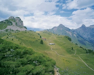
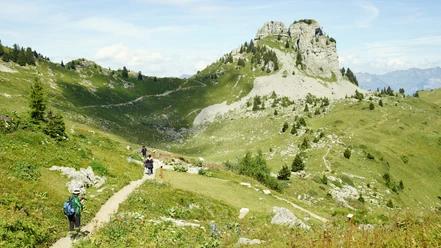
At the Breitlauenen station, which offers a wonderful view of Lake Brienz and Lake Thun, the pre-Alpine peaks of Brienzer Rothorn, Augstmatthorn, Hohgant, and Niederhorn, the hiking route branches off from the railway line along the slope into the forest and then leads steadily uphill on a well-developed gravel path. The first third of the route runs in the pleasant shade of mixed forest. In between, there are already beautiful views of Lake Brienz and the flat settlement area between Lake Thun and Lake Brienz, the Bödeli. Soon the forest thins out and the path crosses some steep ravines. The view gradually widens to the entire Lauterbrunnen Valley. In the broad terrain basin of Alp Bigelti, one gains altitude parallel to the tracks of the Schynige Platte Railway and finally reaches the destination, Schynige Platte, after one last curve. The panoramic view offered here is overwhelming: towards the east lies the valley of the Schwarzen Lütschine with Grindelwald, to the south the valley of the Weiße Lütschine with Lauterbrunnen in the valley bottom and the small village of Isenfluh on the foreland slope. Between them, behind the green summit of Männlichen, stretches the majestic triad of Eiger, Mönch, and Jungfrau in all their splendor. Ferdinand Hodler immortalized these fascinating perspectives of the grand ice and rock giants in several wonderful paintings.
Author: Jungfraubahnen

Good to know
Best to visit
Directions
Equipment
We recommend the following equipment: sturdy mountain boots, medium-sized backpack with hip belt, sun protection, rainwear, hiking poles, first aid kit, picnic, sufficient fluids, mobile phone.
Directions & Parking facilities
Via Bern or Lucerne to Interlaken. Or from the south via Grimsel Pass (summer only), or via Simplon Pass and Lötschberg car shuttle to Interlaken. Wilderswil is located near the exit towards Grindelwald / Lauterbrunnen.
Uncovered parking lot behind the Wilderswil station.
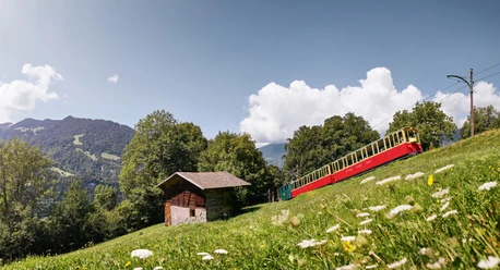
By Bernese Oberland Railway or car to Wilderswil. Then by the historic Schynige Platte Railway to Breitlauenen. Return trip also by the Schynige Platte Railway.
Additional information
Berner Wanderwege, 031 340 01 01, info@beww.ch, bernerwanderwege.ch
License (master data)
Safety guidelines
This route runs entirely or partially on marked paths of the category mountain hiking trail.
Some short, slightly exposed sections are secured with railings.
Map
swisstopo map: 254 T Interlaken, 1: 50,000
Nearby


