Vertikal Beatenberg - Black 1


- 1:30 h
- 5.33 km
- 828 m
- 52 m
- 1,233 m
- 2,061 m
- 828 m
- Start: Hohwald parking lot, Beatenberg
- Destination: Gemmenalphorn
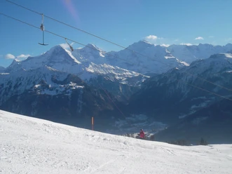
The Vertikal Beatenberg trail running route starts at the Hohwald parking lot. It is a route for experienced runners and classified as difficult. After about 800 meters slightly downhill, it goes vertically through the idyllic Rischerli up to the Chüematte over Oberberg to the Gemmenalphorn. In about 1.5 hours, the summit on the Güggisgrat with views of the Justistal, Emmental, and the Bernese Alps is reached.

Good to know
Pavements
Best to visit
Directions
Equipment
Basic equipment for trail running
- Clothing in a multi-layer principle with moisture transport
- Comfortable running shoes and running socks
- Trail running/running backpack
- Sun, rain, and wind protection (hat, sunscreen, waterproof and windproof jacket and pants)
- Sufficient provisions and drinking water
- Sunglasses
- Blister plasters
- Headlamp
- Mobile phone
- Cash
- Navigation device/map and compass
The lists for "basic equipment" and "technical equipment" are compiled based on the selected activity. They do not claim to be complete and serve only as suggestions for what you should pack.
For your safety, you should carefully read all instructions for proper use and maintenance of your device.
Please make sure that your equipment complies with local laws and does not contain any prohibited items.
Directions & Parking facilities
Bus connection from Interlaken West station towards Beatenberg to the Beatenberg, Waldegg stop
From the Waldegg stop, it goes 1 kilometer up towards the Hohwald parking lot (follow signs), where the start of the trail is located.
Additional information
Spirenwaldstrasse 168
3803 Beatenberg
Tel.: +41 33 841 18 18
info@beatenbergtourismus.ch
www.beatenberg.ch
Interlaken Tourism
Marktgasse 1
3800 Interlaken
License (master data)
Nearby


")
")