Trail 03 – Trailrunning Beatenberg


- 1:45 h
- 9.40 km
- 342 m
- 340 m
- 1,109 m
- 1,409 m
- 300 m
- Start: Hohwald car park, Beatenberg
- Destination: Hohwald car park, Beatenberg
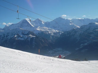
The route leads you up to 1409 metres over the first 1.6 kilometres, then down to 1100 metres over 3.4 kilometres where a slight ascent to 1325 metres over the next 4 kilometres must be mastered.

Good to know
Best to visit
Equipment
Basic equipment for trail running
- Clothing in multi-layer principle with moisture transport
- Comfortable running shoes and running socks
- Trail running / running backpack
- Sun, rain and wind protection (hat, sunscreen, water- and windproof jacket and trousers)
- Sufficient provisions and drinking water
- Sunglasses
- Blister plasters
- Headlamp
- Mobile phone
- Cash
- Navigation device / map and compass
The lists for the "basic equipment" and the "technical equipment" are created based on the selected activity. They do not claim to be complete and serve only as suggestions on what you should pack.
For your safety, you should read all instructions carefully for the proper use and maintenance of your device.
Please make sure that your equipment complies with local laws and does not include prohibited items.
Directions & Parking facilities
Bus connection from Interlaken West station towards Beatenberg to the stop Beatenberg, Waldegg.
From the Waldegg stop, go up 1 kilometre towards the Hohwald car park (follow signage), where the start of the trail is located.
Additional information
Spirenwaldstrasse 168
3803 Beatenberg
Tel.: +41 33 841 18 18
info@beatenbergtourismus.ch
www.beatenberg.ch
Interlaken Tourism
Marktgasse 1
3800 Interlaken
License (master data)
Nearby


")
")

Download GPX file