- 1:50 h
- 5.08 km
- 320 m
- 320 m
- 1,237 m
- 1,525 m
- 288 m
- Start: Wengen
- Destination: Wengen
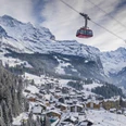
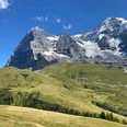
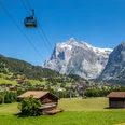
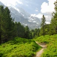
From the Wengen train station, the town center is crossed via Dorfstrasse. Shortly before the church, turn uphill and initially follow the small road, then steeply on a staircase path and, with a lesser incline again, on a shady forest path upwards. Along the flank of the Männlichen, the route winds slowly downhill in several wide turns. A stop is worthwhile at the Äussere Allmend: the view of the elongated, deeply incised Lauterbrunnen Valley is magnificent. The scene is dominated by the majestic Jungfrau massif. Through fragrant alpine meadows and shady mountain forest, you reach the Leiterhorn. The viewpoint offers a wonderful panoramic view of the Lauterbrunnen Valley. A number of benches and a well-equipped fireplace invite you to rest. Contrary to what the place name suggests, the Leiterhorn is not an actual mountain. After all, the terrain falls steeply towards Zweilütschinen and the Bödel region. Therefore, there is also a magnificent view to the north. To enjoy this, walk up for another five minutes in the forest and arrive at a viewpoint with railings. The descent to Wengen proceeds along the forest edge with a wonderful view down the valley to the Hunnenflue viewpoint. From there, it goes back to the village center of Wengen.

Good to know
Pavements
Best to visit
Directions
Wengen - Ussri Allmi - Leiterhorn - Hunnenflue - Wengen
Equipment
We recommend the following equipment: lightweight trekking shoes, light backpack, sun protection, rain jacket, pocket first aid kit, light picnic, sufficient fluids, mobile phone.
Directions & Parking facilities
Additional information
Bernese Hiking Trails, T 031 340 01 01, info@beww.ch, bernerwanderwege.ch
Literature
Hiking suggestion from the hiking book 'Short Walks 1', hiking book series of Bernese Hiking Trails
License (master data)
Safety guidelines
This route runs entirely on hiking trails.
Map
Swisstopo hiking map 1:50,000 254T Interlaken
Nearby