Over the Rotache to an old bath and into the Zulg valley
- 1:40 h
- 6.09 km
- 160 m
- 150 m
- 577 m
- 721 m
- 144 m
- Start: Brenzikofen
- Destination: Steffisburg
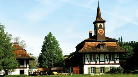
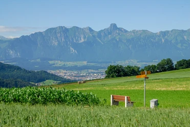
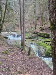
There used to be dozens of baths in the canton of Bern. Names like Gurnigelbad or Rohrimoosbad still recall this old tradition today. The bathing operation of that time had nothing to do with today's wellness. There were neither light-filled bath halls nor sophisticated whirlpools and elaborate massages. The guests – many of whom suffered from anemia, rheumatism or nervous ailments – simply lay in large bathtubs. The water was heated with the plentiful wood found in these areas. A similar “bedli” was also in operation at Schnittweiter near Steffisburg. It dates back to the 15th century. The Interlaken monastery had initially created ponds there for fish farming. The bath simultaneously created for the monks later passed into private hands. Due to the excesses often common at such places, it was at times considered quite disreputable. By the end of the 19th century, however, Schnittweier had become a reputable spa and health resort. Today, the area is only used as an inn and riding school. It is reached from the most centrally located Bernese village: Brenzikofen lies near the geographical center of the canton of Bern (located below the nearby Falkeflue). From the train station, a gravel path runs parallel to the railway line southwards to the Wydeli campsite; from there, it continues on an asphalt lane to the road junction at the Rotache. Here, you leave the traffic behind and follow the stream through the forest. Shallow spots and deep basins in the Rotache invite playing and paddling, even swimming on hot summer days. A footbridge crosses the water, then you ascend through a hollow path. Soon, the idyllic forest clearing comes into view, at the exit of which lies the Schnittweierbad. There, a meadow path branches right off the road and leads to the nearby Schnittweiterhöhe, which offers a magnificent view of Thun castle and town with the striking Niesen pyramid in the background. After a short descent past Muri, you reach the first houses and shortly thereafter the church of Steffisburg.

Good to know
Pavements
Best to visit
Directions
Equipment
We recommend the following equipment: light trekking shoes, light backpack, sun protection, rain jacket, pocket first aid kit, light picnic, sufficient fluids, mobile phone.
Directions & Parking facilities
Outbound: By train via Thun to Brenzikofen station
Return: From Steffisburg by bus to Thun station
Additional information
Literature
Hiking suggestion from the book Short Walks, hiking book series of the Bernese Hiking Trails
License (master data)
Safety guidelines
This route runs entirely on paths categorized as hiking trails.
Map
Swisstopo hiking map 1:50,000 253T Gantrisch
Nearby