Leiterhorn Trail - Wengen (signposted)


- 2:30 h
- 4.72 km
- 250 m
- 250 m
- 1,275 m
- 1,524 m
- 249 m
- Start: Wengen - Hunnenfluh
- Destination: Wengen
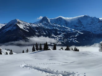
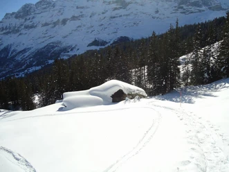
A relatively flat path leads from the village center of Wengen via Ledi to Hunnenfluh. Along the way, the path offers breathtaking views of the Lauterbrunnen valley. From Hunnenfluh, you enjoy a great view into the Lütschental and further down to Interlaken. From here, it is time to strap on the snowshoes. Through a wild romantic forest, you then ascend for 20 to 30 minutes up to Leiterhorn. Along the way, the deep snow-covered path offers views of Wengen and the mighty Jungfrau. Once you have reached Leiterhorn, an incredible view of the 4000-meter mountain range and the deep Lauterbrunnen valley awaits you. Those without vertigo can enjoy, on the north side, an impressive, almost 700-meter vertical view down to Zweilütschienen. The return route then leads via Ussri Allmi and Lägerweidli over a not too steep forest path down to Wengen.

Good to know
Pavements
Best to visit
Equipment
We recommend the following equipment: sturdy and waterproof mountain boots, light to medium backpack, cold protection, sun protection, trekking poles, first aid kit, snacks, tea in a thermos, mobile phone.
Directions & Parking facilities
By car via Interlaken to Lauterbrunnen. From there by train to Wengen.
Large parking garage in Lauterbrunnen
Arrival and departure: By train via Interlaken to Lauterbrunnen and onward to Wengen.
Additional information
Verein Berner Wanderwege, Bern, Tel.: 031 340 01 01, E-Mail: info@beww.ch, Homepage: www.bernerwanderwege.ch
License (master data)
Safety guidelines
This route is signposted as a snowshoe route but not specially prepared.
Map
Swisstopo Landeskarte 1229 Grindelwald 1:25’000
Nearby


Download GPX file