Isenfluh - armchair of the Bernese Oberland


- 3:10 h
- 8.08 km
- 419 m
- 855 m
- 1,085 m
- 1,883 m
- 798 m
- Start: Isenfluh/Sulwald
- Destination: Isenfluh
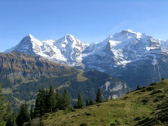
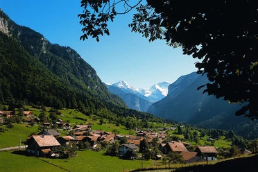
The mountain village of Isenfluh is located just under 1100 meters above sea level and thus about four hundred meters above the valley of the white Lütschine. The description on the Internet that from Isenfluh you have a magnificent view of the Jungfrau and that with the Sulwaldfluh behind you feel like in an armchair is true. Since January 1, 1973, Isenfluh has belonged to the municipality of Lauterbrunnen, which has since included politically and geographically the entire valley area with Wengen, Stechelberg, Mürren and Lauterbrunnen. Thus, it rose to become the then third largest municipality in terms of area in the canton of Bern.
The aerial cableway takes hikers from Isenfluh to Sulwald, saving about 435 meters of ascent. From the mountain station, choose the path towards Lobhornhütte. The route runs with a steady incline through meadows and through the Guferwald past Chüebodmi. At Fritzenbrüggli below Suls, the highest point of the hike is reached. Here you cross the Sulsbach on the wooden footbridge towards Flöschwald. After a bend in the path, the view opens up to Eiger, Mönch and Jungfrau. Now pay attention to the red-white-red marking on stones to not miss the descent to Sousläger and into the Soustal. After crossing the Sousbach on a wooden bridge, the hike continues on the route back to Isenfluh, across an alpine pasture, a forest road and a forest path.

Good to know
Pavements
Best to visit
Directions
Isenfluh/Sulwald – Suls – Sousläger - Isenfluh
Directions & Parking facilities
Return: By post bus to Lauterbrunnen, by train to Interlaken and further
License (master data)
Nearby

Download GPX file