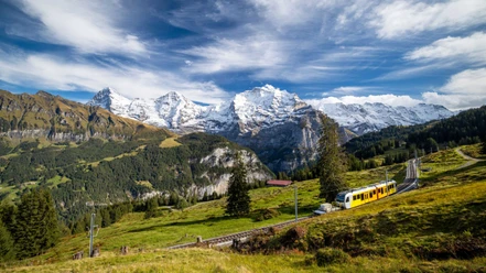
Hiking in the presence of Eiger, Mönch and Jungfrau


- 3:50 h
- 11.91 km
- 590 m
- 590 m
- 1,487 m
- 1,926 m
- 439 m
- Start: Grütschalp, aerial cableway
- Destination: Grütschalp, aerial cableway
At the starting point of the hike, head towards Allmendhubel. Up to this intermediate destination, the route is also called Mountain View Trail, probably as a convenience for English-speaking tourists. After a short stretch on pastureland, turn right onto a path. Now follows a longer ascent through forest and alpine meadows. Suddenly, you reach the Bletschenalp. From here, a ridgeway-like section follows. Alongside views of Eiger, Mönch and Jungfrau, there are views of countless mountain peaks such as the Mittags- and Breithorn or the mid-station Birg of the Schilthorn cable car. On the other side of the Lauterbrunnen valley, the peaks Lauberhorn, Tschuggen and Männlichen can be seen. Below, the holiday resort Wengen, embedded in a hollow, can be spotted. The Faulhorn, the Schynige Platte and the Augstmatthorn are also visible. After a short steeper ascent, turn left at the Hohlücke signpost towards Allmendhubel. Here, children enjoy the large adventure playground. A panorama board makes it easier to name the numerous peaks. The Allmendhubelbahn offers a shortcut to Mürren. The next intermediate destination is the BLM station Mürren; also note the railway symbol on the signposts. The route alternates between steeper and less steep sections. The additional note Panoramaweg helps to find the right path in the dense hiking trail network. The last section from Mürren to Grütschalp is easy to walk. Signposted as a hiking trail, it offers an alternative for a short and relaxed hike.

Good to know
Pavements
Best to visit
Directions
Grütschalp - Bletschenalp - Allmendhubel - Mürren - Winteregg – Grütschalp
Equipment
We recommend the following equipment: sturdy and waterproof mountain boots, light to medium backpack, cold protection, sun protection, hiking poles, pocket first aid kit, snacks, tea in a thermos bottle, mobile phone.
Directions & Parking facilities
Outbound journey: By train to Interlaken Ost, then to Lauterbrunnen and further by aerial cableway to Grütschalp
Return journey: By aerial cableway to Lauterbrunnen, then to Interlaken Ost
Additional information
Bernese Hiking Trails Association, Bern, Tel.: 031 340 01 01, E-mail: info@beww.ch, homepage: www.bernerwanderwege.ch
Literature
Hiking book Panoramic hikes of the Bernese hiking trails
License (master data)
Safety guidelines
This route runs wholly or partly on marked trails of the mountain hiking trail category.
Map
Swisstopo hiking map 1:50,000 254T Interlaken
Nearby


")