In the source area of the Waldemme


- 3:30 h
- 7.15 km
- 1,150 m
- 120 m
- 1,240 m
- 2,348 m
- 1,108 m
- Start: Sörenberg, Rothorn cable car valley station
- Destination: Brienzer Rothorn
On the alpine pastures on the northern slopes of the Brienzer Rothorn, the water of the Waldemme springs to the surface from several sources. Several small water arms unite into a white-foaming mountain stream, which spectacularly leaps over rock steps at the Emmensprung into the depths. The hiking trail leads from the valley station of the Rothorn cable car towards Eisee and Brienzer Rothorn. At the Emmensprung, the hiking trail crosses a bridge with the best view of the rushing waterfalls.
On its way from Entlebuch to the mouth into the North Sea, the Waldemme joins with the Wiss Emme at Schüpfheim and flows as the Kleine Emme to Emmenbrücke. There, its water is taken up by the Reuss, at Brugg by the Aare and at Koblenz by the Rhine. Hundreds of kilometers later, the Rhine and thus the water from the slopes above Sörenberg reaches the sea at Rotterdam.
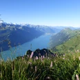
After the source area at the Emmensprung, the hiking trail continues uphill to the green Eisee, nestled in a hollow. Almost daily, fishermen wait on the shore for rainbow, brook trout or char to bite. The sunny terrace of the Eisee mountain hut invites you to take a break. From here, it is not many more altitude meters to the Eisee saddle on the Brienzer ridge. On the southern side, the white snow-covered Bernese Alps present themselves, and there is an impressive view down to the milky-blue Lake Brienz. A scenic, well-built ridge trail leads along the ridge shoulder and flanks further up to the lofty summit of the Brienzer Rothorn with overwhelming views in all directions. Beyond the Black Forest, you can see in the distance the further course of the small stream that originates on the northern side of this summit. Text: Sabine Joss

Good to know
Pavements
Best to visit
Directions
Equipment
Directions & Parking facilities
Outbound: PostBus to Sörenberg, Rothorn cable car
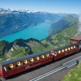
Return: from Brienzer Rothorn by cable car to Sörenberg or by cogwheel railway to Brienz
Additional information
License (master data)
Safety guidelines
Map
Nearby
