Holenstein - Bustigeln - Kleine Scheidegg No. 31


- 2:10 h
- 5.68 km
- 506 m
- 71 m
- 1,613 m
- 2,049 m
- 436 m
- Start: Holenstein station
- Destination: Kleine Scheidegg station
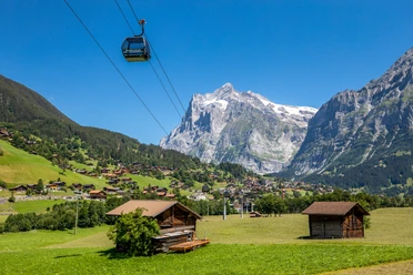
From the Holenstein station, accessible from Wengen via the Männlichenbahn and GGM or from Grindelwald Grund with the GGM, the mostly flat hiking trail leads to the Bustiglen junction. From here, it steadily goes uphill until reaching Kleine Scheidegg station.

Good to know
Pavements
Best to visit
Directions
A wide hiking trail that gently slopes downward, flat until Bustiglen.
From the Bustiglen junction, steadily climb until Kleine Scheidegg.
Equipment
- The sun exposure in the mountains is particularly intense. Sunscreen with a high protection factor, a sun hat, and sunglasses with UV protection should therefore be part of your gear.
- Even in summer and in good "starting weather," warm clothing and rain protection are part of the equipment. The layering principle with multiple layers is recommended.
- Day hiking backpack with rain cover
- Sturdy and comfortable footwear
- Weather-appropriate and durable clothing (layering principle)
- Charged mobile phone
- First aid kit
- Drinks and food
- Pocket knife
Directions & Parking facilities
From Basel and Geneva, the fastest route to the Jungfrau Region is via Bern. From Zurich, the route via Lucerne and the Brünig Pass is recommended. The pass is open year-round.
From the south, arrival is via the Grimsel or Susten Pass to the Jungfrau Region. Both passes are only open in summer. Alternatively, the Simplon Pass with a subsequent car loading through the Lötschberg tunnel is an option.
Grindelwald
From Interlaken, we follow the main road to Zweilütschinen. Here, we turn left towards Grindelwald. The entire drive takes about 30 minutes and goes over a partly winding road.
Attention:
Wengen
Wengen is car-free. If you arrive by car, you must leave it in Lauterbrunnen and take the train. The ride from Interlaken to Lauterbrunnen takes about 20 minutes.
Grindelwald
There are three public parking garages: Eiger+ Parking Garage (252 parking spaces), Sports Center Parking Garage (160 parking spaces) and the new Terminal Parking (1000 spaces) of the V-Bahn. Alternatively, the parking lot in Grindelwald Grund can be used.
Wengen
Directly below Lauterbrunnen station is a multi-story parking garage. Alternatively, the parking lot near the Lauterbrunnen church can be used. From here, a bus runs to the station every half hour. Walking takes about 10 minutes.
A covered passage leads from the Lauterbrunnen parking garage to the trains to Wengen.
Thanks to its central location in Europe, Switzerland is served by international trains from over 12 countries. Within Switzerland, Intercity trains run directly to the Jungfrau Region from Basel and Lucerne. Travelers from Zurich change trains in Bern. The trains run every half hour.
Grindelwald
From Interlaken Ost station, we reach Grindelwald without changing trains via the Bernese Oberland Railway (BOB). Important: board the rear part of the train, as it splits in Zweilütschinen. Those boarding at the front end up in Lauterbrunnen. The journey takes 30 minutes to Grindelwald Terminal (V-Bahn). Three minutes later, we arrive at the terminal station in the village.
Grindelwald has three stations (Terminal, Grund, and Dorf). The terminal station (Dorf) is located in the center of Grindelwald.
Wengen
From Interlaken Ost station, we reach Wengen in 44 minutes. With the blue-yellow train of the Bernese Oberland Railway (BOB), we go to Lauterbrunnen. Important: We sit in the front part of the train, as it splits in Zweilütschinen. Those seated in the rear make a detour to Grindelwald. In Lauterbrunnen, we change to the yellow-green train of the Wengernalp Railway (WAB). It takes 12 minutes to Wengen.
Additional information
License (master data)
Author´s Tip / Recommendation of the author
Upon arrival at Kleine Scheidegg, enjoy a small refreshment and the view.
Safety guidelines
- Regularly check your location and compare it with the schedule. This allows you to consider alternatives, shortcuts, or abort the hike in time.
- If bad weather sets in, turn back or seek shelter in time. If thunderclouds appear, it is advised to end the hike as quickly as possible.
- Do not leave marked trails. Stay on official hiking paths even if some trails look like shortcuts. Some of these paths are not maintained and may end in a dead end.
- Lost? Stay together as a group and return to the last known point. Wait for better visibility or call for help.
- Plan enough time and energy reserves for the descent.
- Reduce your pace and take breaks.
- Steep grassy, scree, and snow slopes are safer to manage going up than descending.
- If necessary, choose the easier variant for descent or take the train down.
- Pass cattle herds calmly and with enough distance. Keep dogs on a leash.
- When encountering livestock guardian dogs: stay calm so the dog notices you are not a threat to the herd. Pass the herd with generous distance.
- Let mountain bikers pass without unnecessarily obstructing their ride.
Nearby