Blueme II


- 3:15 h
- 27.91 km
- 847 m
- 847 m
- 558 m
- 1,390 m
- 832 m
- Start: Thun, train station
- Destination: Thun, train station
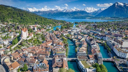
A great route that does not shy away from technical challenges. Additionally, the view over the Bernese Alps, the deep blue Lake Thun, and far out into the Mittelland and Emmental is excellent. Past Steffisburg, along the Fischbach, through beech trees, it goes from Multenegg into the forest. The path becomes a forest road and it gets steeper. The descent from the viewpoint «Blueme» is long, fun and unforgettable. From Oberhofen, the path leads back along the lake to Thun.

Good to know
Best to visit
Directions
Additional information
Information on duration, fitness, and technique depends on the chosen type of bike (mountain bike, e-bike, e-mountain bike, touring bike, road bike). These are average reference values.
Thun-Thunersee Tourism
Seestrasse 2
3600 Thun
Tel. +41 33 225 90 00
thun@thunersee.ch
www.thunersee.ch
Interlaken Tourism
Marktgasse 1
3800 Interlaken
Tel. +41 33 826 53 00
mail@interlakentourism.ch
www.interlaken.ch
License (master data)

Safety guidelines
Nearby


Download GPX file