To the secluded Abländschen

- 3:45 h
- 11.05 km
- 670 m
- 610 m
- 1,230 m
- 1,794 m
- 564 m
- Start: Schönried
- Destination: Abländschen
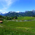
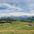
From Schönried station to the main road, cross it and then ascend uphill. Subsequently, gently climbing northward to Bergmatte (20 min to Saanenmöser). On the way, magnificent views over Saanenmöser to the rocky peaks of Hindere Spillgerte. To the south, the Saane valley with the Oldenhorn. With slight inclination, the path approaches the Kleine Simme road. Continuing moderately uphill over pastures and among spruce groups into the valley. At Simne, you switch to the opposite side of the stream. Soon the alpine road starts to climb more steeply uphill, the rushing of the stream becomes quieter. Near the massive high-voltage line, which runs from Valais over the Sanetsch Pass and through the Saanenland into the Mittelland, the path winds up to the Bire alpine hut (2h45 to Rellerligrat–Saanen; 2h40 to Rellerligrat–Schönried; 2h20 to Hinderi Schneit–Abländschen, partly on asphalt). In clear weather conditions, from here above the Sanetsch Pass, the broad massif of the Grand Combin in the Valais Alps can be seen.
Cross a hollow with slight ups and downs off-path and on trail traces, and head toward the forest (not to the Gruebe alpine hut). In the light woodland, the trail traces become clearer. Pristine and wild is the slope of Schwylaub, covered with green alders, bird cherry trees, and lichen-covered conifers, fern-covered, through which the path leads down to the Jäunli. At the bridge in Hindere Schwand on this side of the stream, stay and only cross to the other side after the farm. Ascend to the road and follow it to the scattered houses on the slope of Abländschen at the foot of the Gastlosen and to the over 500-year-old chapel. The place name derives from a Celtic word meaning "pasture by the stream," whereas the row of peaks of the Gastlosen owes its name to the Romance "castello."

Good to know
Pavements
Best to visit
Directions
Equipment
Directions & Parking facilities
Additional information
Literature
License (master data)
Safety guidelines
Map
Nearby