To the enchanting Bachsee


- 3:00 h
- 8.83 km
- 276 m
- 760 m
- 1,796 m
- 2,404 m
- 608 m
- Start: First, cable car
- Destination: Bussalp
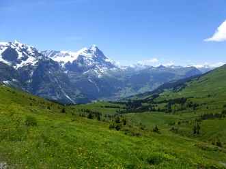
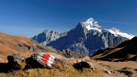
At the mountain station of the First cable car, a special attraction awaits: The First Cliff Walk by Tissot. A suspension bridge and a walkway lead around the rock head. They allow impressive views of the majestic mountain world. To be admired are the Eiger, a waterfall, alpine pastures as well as forests. It seems as if Mönch and Jungfrau hide behind the Eiger. On the signpost at the starting point of the hike, the destination Bussalp as well as the intermediate destinations Bachsee and Spitzen are marked. Hence, the route can be found easily. The first section to Bachsee is marked as a hiking trail. The ascent proceeds leisurely on a forest road past a moor landscape. The view of the two lakes is enchanting. No wonder that the path from First to here is a popular excursion. Then it continues upwards on a path marked as a mountain hiking trail. At Spitzen you turn right and reach the Fernandes hut via a ridge. According to the inscription it was built after 1992. Now the hike goes downhill through scree and boulder fields, later over alpine pastures. Steeper or flatter, the route leads past Alp Feld to Oberläger. Now the Mönch and Jungfrau can also be seen. Further on are Kleine Scheidegg, Lauberhorn, Tschuggen, and Männlichen. Over a steep descent through alpine pastures you reach the destination Bussalp.

Good to know
Pavements
Best to visit
Directions
First - Bachsee - Spitzen - Feld - Oberläger – Bussalp (3h)
Equipment
We recommend the following equipment: sturdy and waterproof mountain boots, light to medium backpack, cold protection, sun protection, hiking poles, pocket first aid kit, snacks, tea in a thermos flask, mobile phone.
Directions & Parking facilities
Outbound trip: By train via Interlaken Ost to Grindelwald and cable car up to First
Return trip: By bus from Bussalp to Grindelwald, then by train
Additional information
Bernese Hiking Trails Association, Bern, Tel.: 031 340 01 01, E-Mail: info@beww.ch, Homepage: www.bernerwanderwege.ch
Literature
Hiking book Panoramic Hikes of the Bernese Hiking Trails
License (master data)
Safety guidelines
This route runs entirely or partly on marked trails of the mountain hiking path category
Map
Swisstopo hiking map 1:50,000 254T Interlaken
Nearby

")