To idyllic mountain lakes in beautiful alpine landscape


- 4:20 h
- 12.20 km
- 580 m
- 990 m
- 1,130 m
- 1,919 m
- 789 m
- Start: Col du Pillon
- Destination: Feutersoey / village
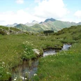
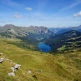
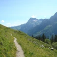
From Gstaad the post bus takes us past Feutersoey and Gsteig through the beautiful landscape to the starting point Col du Pillon in the canton of Vaud. Most post bus passengers rush to the Glacier 3000 cable car station. We start with the hiking route 46 «Tour des Alpes Vaudoises» heading towards Lac Retaud – Col de Voré – Arnesee – Feutersoey. Soon the path becomes quite steep and after about half an hour you reach the small lake Lac Retaud, idyllically embedded in the landscape. After a short rest, it continues on a short, fairly flat section. Afterwards, you cross an old avalanche zone and tackle the last ascent to the highest point of the hike (1918 m above sea level), Col de Voré. The alpine flora is beautiful and from the pass height you enjoy a magnificent panoramic view of the Diablerets mountain range and the Cape au Moine. On a good path it then goes gently downhill past peat pools and a small lake inhabited by ducks and coots. From afar you can see the reservoir Arnesee with the Tschärzisbach as inflow and outflow. From Alp Seeberg you descend to the lake and follow the pleasant beautiful shore to the dam. A break with a view of the lake is relaxing. From the dam you head towards Hindere Walig – Tuxberg. In places you walk over soft, often wet moor ground. Hard surface is only on the last half kilometer to Feutersoey. Full of impressions from the interesting route, we board the post bus at the village stop, which takes us back to Gstaad train station. Depending on the transfer time, you can still explore the beautiful, well-maintained upscale resort.
Text: Walter Gerber

Good to know
Pavements
Best to visit
Directions
Col du Pillon – Lac Retaud – Col de Voré – Arnesee – Feutersoey
Equipment
We recommend the following equipment: sturdy mountain boots, medium-sized backpack with hip belt, sun protection, rain clothing, hiking poles, pocket first aid kit, picnic, sufficient fluids, mobile phone.
Directions & Parking facilities
Arrival: by post bus from Gstaad / train station to Col du Pillon
Return: by post bus from Feutersoey / village to Gstaad / train station
Additional information
Berner Wanderwege, 031 340 01 01, info@beww.ch, bernerwanderwege.ch
License (master data)
Author´s Tip / Recommendation of the author
Blattipass variant
Described in the BWW hiking book «Panoramic hikes», Fritz Brönnimann, ISBN 978-3-9522983-7-4:
from Alp Seeberg via Obers Stuedeli – Blattipass (1919 m) to Gsteig
Safety guidelines
This route runs entirely or partially on marked paths of the category mountain hiking trail.
Map
262T Rochers de Naye, 1 : 50 000
263T Wildstrubel, 1 : 50 000
Nearby