Through diverse nature on the Sillerebüel


- 2:50 h
- 7.53 km
- 700 m
- 70 m
- 1,295 m
- 1,975 m
- 680 m
- Start: Adelboden/Post
- Destination: Sillerenbühl
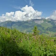
Despite tourism, Adelboden has remained a charming village that offers a wide variety of nature in its surroundings. That there is still a lot of forest above the village is not a given. In earlier times, a lot of forest was cleared to gain pastureland and wood for construction – too much. Already in the 16th century, ordinances had to be issued to protect the forest. Due to excessive clearing, the valley was threatened by landslides and avalanches. You could start the hike already at the Adelboden/Mineralquelle stop, but a walk through the chalet village is worthwhile – so: continue to Adelboden/Post. Maybe there is even a starting coffee or a specialty from a bakery. Towards the end of the village, the hike leads down into the incision of the Allebach and along its stream bed. From Rehärti, the path continues following the Allebach – sometimes close to the bank, sometimes somewhat elevated above steep slopes affected by erosion, and through small moor areas with orchids and cotton grass. Shortly after, you reach the hamlet of Aebi with the restaurant of the same name. However, during the off-season, this is mostly closed. From here, the trail really ascends and winds through flowery meadows, through forest sections with a rich ground vegetation, over alpine pastures with alpine roses and finally with magnificent mountain views up to the Sillerebüel. With mountain panorama and hospitality on the sun terrace, one can linger for a long time here. Those who want to hike about an hour longer can follow the flower path from Sillerebüel to the Hahnenmoospass with slight ups and downs. There, too, a restaurant and a cable car await.
Text: Fredy Joss

Good to know
Pavements
Best to visit
Directions
Adelboden – Rehärti – Aebi – Chüebodmi – Sillerebüel
Equipment
We recommend the following equipment: sturdy mountain boots, medium-sized backpack with hip belt, sun protection, rainwear, trekking poles, first aid kit, picnic, sufficient fluids, mobile phone.
Directions & Parking facilities
Arrival: by bus from Frutigen to Adelboden / Post
Return: by gondola from Sillerenbühl to Adelboden / Oey (Sillerenbahn), 5 minutes on foot, by bus from Adelboden / Mineralquelle
Additional information
Berner Wanderwege, 031 340 01 01, info@beww.ch, bernerwanderwege.ch
License (master data)
Safety guidelines
This route runs wholly or partly on signposted paths of the category mountain hiking trail.
Map
swisstopo hiking map: 263T Wildstrubel, 1 : 50 000
Nearby

