


- 2:30 h
- 4.55 km
- 600 m
- 97 m
- 1,615 m
- 2,190 m
- 575 m
- Start: Chrindi
- Destination: Stockhorn
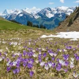
Most hikers descend from Chrindi directly to Hinderstockensee. Our route, however, leads behind the Chrindi restaurant along the well-secured rock path on the south side around the lake, with a beautiful view of the island, then down and up to Stockhorn.
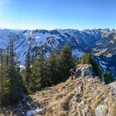
At Hinderstockenalp, the path ascends. There is a direct path to Oberstockenalp, but it is more rewarding first to head towards Oberstockensee to the junction P. 1734 and then ascend to Oberstockenalp. This way, you also have a nice view of Oberstockensee.
The sunny terrace of Oberstockenalp tempts for a break. Or is there still enough energy for the summit restaurant? There you will also find the panoramic platform with a glass floor and, of course, the summit with its 360-degree panoramic view and the alpine garden. Romans have already stood up here, as finds of Roman coins prove. Even further down, people passed through 30,000 years ago. In a cave near Oberstockensee, archaeologists found Paleolithic tools.

Good to know
Pavements
Best to visit
Equipment
Mountain hiking equipment
Directions & Parking facilities
By car to Erlenbach in Simmental.
Parking spaces at the Stockhorn cable car.
Train to Erlenbach in Simmental, 15 min walk to the Stockhorn aerial cableway, ride to Chrindi.
Aerial cableway from Stockhorn to Erlenbach.
Additional information
Stockhornbahn AG, 033 681 21 81, stockhorn.ch
Literature
Sabine Joss / Fredy Joss: The 77 most beautiful high and panoramic hikes. ISBN 978-3-03865-074-4, Rothus Medien, Solothurn, www.wandershop-schweiz.ch
Sabine Joss / Fredy Joss: The 77 most beautiful hikes to cable car and bus. ISBN 978-3-03865-104-8, Rothus Medien, Solothurn, www.wandershop-schweiz.ch
Sabine Joss / Fredy Joss: The 88 most beautiful summit routes of Switzerland. ISBN 978-3-03865-071-3, Rothus Medien, Solothurn, www.wandershop-schweiz.ch
More about Fredy Joss: www.fredyjoss.ch
License (master data)
Author´s Tip / Recommendation of the author
A long route is planned for those starting directly at Erlenbach station. For example, the ascent via the hamlet of Thal to Chrindi is nice, about 960 m elevation gain, 3 hours, T2.
Safety guidelines
Difficulty T2. No fear of heights on the rock path.
Map
Map 1:50,000, 253T Gantrisch
Nearby


")
")
")