


- 3:00 h
- 7.37 km
- 550 m
- 550 m
- 1,110 m
- 1,642 m
- 532 m
- Start: Saxeten, Bushaltestelle
- Destination: Saxeten, Bushaltestelle
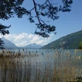
To the northeast, the valley at the foot of the Schwalmere opens onto a magnificent view of Lake Brienz. Here, time passes slowly. The valley is mainly given over to agriculture; cultivated zones created and maintained by the locals blend easily into the landscape of untamed mountains.
From the PostBus stop at the old school, the route leads out of the village, climbing steeply over pastureland to the Ankere-Wald. A less steep, winding forest path leads on to Blattisegg, where hikers enjoy beautiful views of Lake Brienz and the Augstmatthorn mountain.
An almost flat, old smugglers' path then runs into the valley to the Ausserberg hut. From here, the official hiking trail leads back down through forest to the village – a little too soon, in fact. It is therefore better to ignore this path and follow the wide gravel road into the valley. Passing the hut on Alp Fahl, you continue gently downhill to the little hut on the Ramsermatte. The marked trail then continues steeply down to Holderboden, from where you return to Saxeten on a surfaced road – but first, it’s worth taking a closer look at the Ramsermatte. In spring, this mountain meadow, nestling harmoniously into the slope, is a veritable floral paradise.
Note(s)
In 2012, this uniquely idyllic place was awarded the Cultivated Landscape Prize for the East Oberland region. Part of the expansive area of pastures is mowed, but most of it is used for grazing; in between are wetlands and dry grasslands. The sheer range of habitats supports an abundance of biodiversity, as evidenced by the numerous butterflies on the Ramsermatte.
Every year, the «Kulturlandschaftspreis» (Cultivated Landscape Prize) is awarded to the most beautiful, and most valuable, areas of cultivated landscape in the East Oberland region. By supporting and promoting the area’s image through tourism, the award incentivises farmers to manage their land sustainably and help preserve our beautiful natural environment.
Want to discover yet more hiking trails?
Learn more about the various hiking opportunities in the Bernese Oberland.

Good to know
Best to visit
Directions
Directions & Parking facilities
Additional information
Marktgasse 1
3800 Interlaken
Phone: +41 33 826 53 00
mail@interlakentourism.ch
www.interlaken.ch
License (master data)
Author´s Tip / Recommendation of the author
Nearby