On the panorama high trail Stockhorn–Gantrisch


- 4:20 h
- 11.23 km
- 300 m
- 1,000 m
- 1,579 m
- 2,138 m
- 559 m
- Start: Stockhorn
- Destination: Gurnigel/Wasserscheide
The ascent from the mountain station of the Stockhorn cable car to the viewing platform on the Stockhorn is short but steep. The panoramic and deep views are overwhelming. Most of the high-altitude trail to Leiterepass can also be overlooked. From the starting signpost at the panorama restaurant, pass the launch ramp for paragliders to the cliff edge on the western ridge of the Stockhorn (via Strüssligrat to Oberstocken–Chrindi 1h; caution: climbing sections! Only suitable for sure-footed, experienced mountaineers without fear of heights). Here you turn sharply to the north and ascend very steeply on a good mountain path at the foot of the Stockhorn wall to Baachegg and down a pasture path to the Oberi Walalp mountain hut.
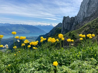
Now the actual high-altitude trail begins on the almost continuously steeply falling southern slope of the Stockhorn-Gantrisch ridge. With slight ups and downs across meadows and through short forest sections, finally passing through a rocky, boulder-lined gorge, you reach the terrace of the Alp Chuelouenen via Stierenhütte and Äust. The path then crosses a long sequence of ridges and ditches, slightly ascending. The botanical diversity on these scarcely grazed, sunny steep slopes is great. Bird species whose main breeding area is in the southern Alps can be observed here. And the landscape is magnificent: across the ridges and hills of the Simme and Diemtigtal, the chain of the high Alps from Wetterhorn (left of the Stockhorn) to Wildhorn is visible. The path runs somewhat monotonously in the flank of Chrummfaden and Nünenenflue between Schiterwang and Leiterepass (via Morgetepass to the Lower Gantrisch Hut 1h40). A plaque at the pass commemorates young people from various countries who built the high trail in 1972/73.
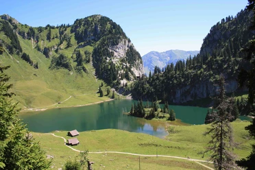
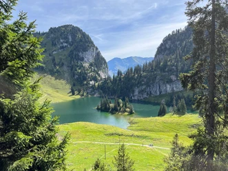
A wide mountain path now leads down into the Alpine basin of Obernünenen, surrounded by the mountain flanks of Gantrisch and the steep cliffs of Nünenenflue. From there, it continues on a forest road to the PostBus station at the watershed (to Gurnigel/Berghaus 30 min).

Good to know
Pavements
Best to visit
Directions
Equipment
Directions & Parking facilities
Outbound journey: By train via Spiez to Erlenbach. On foot (12 min.) to the Stockhorn cable car. Take the train to the summit.
Return journey: By bus to Riggisberg and Turnen. Then continue by train.
> Take advantage of an attractive special ticket from BLS that includes the PostBus ride and the descent with the Stockhorn cable car at a special price.
> To the BLS shop
Additional information
Bernese Hiking Trails, 031 340 01 01, info@beww.ch, bernerwanderwege.ch
Literature
Hiking suggestion from the hiking book Simmental - Saanenland, hiking book series of Bernese Hiking Trails
License (master data)
Author´s Tip / Recommendation of the author
Take advantage of an attractive special ticket from BLS that includes the PostBus ride and the descent with the Stockhorn cable car at a special price.
> To the BLS shop
Safety guidelines
This route runs wholly or partly on mountain hiking trails.
Map
Swisstopo hiking map 1:50,000 253T Gantrisch
Nearby
")
")
")