Iffigenalp - Lac Tzeusier / On historic packhorse trails to Valais


- 5:00 h
- 12.56 km
- 1,250 m
- 812 m
- 1,583 m
- 2,427 m
- 844 m
- Start: Lenk/Iffigenalp
- Destination: Lac de Tseuzier
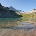
The pass crossing listed in the Inventory of Historic Traffic Routes of Switzerland begins at the mountain hotel on Iffigenalp. Beyond the stream ravine, the path gains height quickly through forest and steep switchbacks. Wonderful views along the way into Obersimmental, to the Spillger massif, Albristhore and Gsür. Passing steep walls and a spraying waterfall, you reach the Blatti hut (shelter hut, no catering!). Over flower-rich meadow edges, after a further steep climb, you reach the high hollow of Stiereläger (to Wildstrubel hut SAC at 2791 m, the highest marked point in the mountain hiking trail network of Obersimmental, 2 hours). With less steep ascent, you enter a small high valley, where a blue-green little lake lies. The strongly karstified parts of the Wildstrubel-Wildhore region here do not show a clear watershed. The nearby Rawil lakes drain, for example, underground both to the Lenk side (Iffigläger spring, Sibe Brünne) and to the Valais side (Source de La Loquesse, Source du Six). Through scree slopes where the large-flowered gentian and Mont-Cenis violet bloom, to the shelter on Rawil Pass. The pass path leads slightly downhill southwards through the furrowed, wide Plan des Roses. Below the gently inclined firn fields of Glacier de Ténéhet and Glacier des Audannes on Wildhore, the bright limestone rock areas of the karst fields stand out. Only during the descent above the valley incision of La Liène do some Valais high Alpine peaks become visible (Weisshorn, Zinalrothorn, Obergabelhorn and Dent Blanche). On the alpine terrace of Armeillon, the stony path joins a wide path. Through a short tunnel, some narrow hairpin bends, and along the foot of the rock wall, the valley floor Lourantse is reached. From water-rich karst springs, tumbling streams emerge from the mountain interior. The last section along the right bank of Lac de Tseuzier is very pleasant to walk. The impressive pass hike ends at the PostBus stop Barrage du Rawil. The short detour to the 156 m high dam is highly recommended!

Good to know
Pavements
Best to visit
Directions
Iffigalp - Stierenläger - Rawil Pass - Armeillon - Lac de Tseuzier
Equipment
We recommend the following equipment: sturdy hiking boots, medium-sized backpack with waist strap, sun protection, rainwear, hiking poles, first aid kit, picnic, sufficient fluids, mobile phone.
Directions & Parking facilities
Arrival: By train via Zweisimmen to Lenk. By bus to Iffgenalp.
Return: By PostBus from Lac de Tseuzier to Sion
Additional information
Bern Hiking Trails Association, Bern, Tel.: 031 340 01 01, E-mail: info@beww.ch, homepage: www.bernerwanderwege.ch
Literature
Hiking suggestion from the hiking book Simmental - Saanenland, hiking book series of the Bern hiking trails
License (master data)
Safety guidelines
This route runs entirely or partly on marked paths of the mountain hiking trail category.
Map
Swisstopo hiking map 1:50,000 263T Wildstrubel
Nearby
