Idyllic mountain lakes at the Stockhorn


- 2:45 h
- 6.86 km
- 520 m
- 520 m
- 1,596 m
- 1,948 m
- 352 m
- Start: Chrindi
- Destination: Chrindi
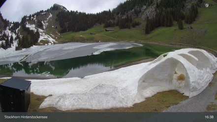
Behind the middle station Chrindi of the Stockhorn cable car, you start on the hiking trail carved into the rock. This path offers a scenic view above the green shimmering Hinterstockesee, partially passing through rock tunnels, leading to the western side of the lake. The small island in the mountain lake proves to be a visual highlight here. At the next junction, keep left towards Vorderstocke. After approximately 120 meters of ascent, take the right turn at the next crossroad and climb steeply and directly up to the Cheibehore, from where you enjoy a magnificent view of the two idyllic mountain lakes and the towering Stockhorn. Downhill, the trail continues along the wide western ridge to the saddle at Vorderstocke (point 1798). To the right, descend to the Oberstockesee which, surrounded by alpine meadows, lies in a hollow between the Stockhorn and the Sattelspitz. The lake is circled halfway counterclockwise, practically mostly along the water. The forest north of the lake is brushed past as you ascend to the Oberstocke Alp, where a wonderful rest stop awaits. Through a karstified, flower-rich forest hollow you reach the Hinterstockesee. There, benches and a larger picnic area invite you to relax. Along the northern shore, you finally ascend back to the middle station Chrindi.
Background: Both the Hinterstocke and Oberstockesee are rich in rainbow trout and are therefore a popular destination for amateur anglers.

Good to know
Pavements
Best to visit
Directions
Equipment
We recommend the following equipment: sturdy hiking boots, medium-sized backpack with hip belt, sun protection, rainwear, hiking poles, first aid kit, picnic, sufficient fluids, mobile phone.
Directions & Parking facilities
Return trip: with the cable car from Chrindi to Erlenbach
Additional information
Literature
License (master data)
Author´s Tip / Recommendation of the author
Safety guidelines
Map
Nearby






Download GPX file