Grüenenberg Pass – from the forest land to the high moor area

- 3:20 h
- 10.53 km
- 560 m
- 530 m
- 1,040 m
- 1,555 m
- 515 m
- Start: Innereriz
- Destination: Habkern
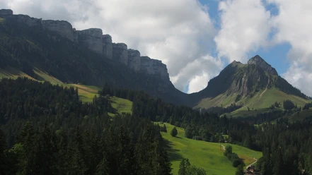
The PostBus route to Innereriz/Säge opens up a recreational area that is extremely popular among nature lovers. The nearby, especially beautiful high moor of Rotmoos and the massive valley end with the mighty rock bands of Hohgant are unique. A road runs along the Fallbach through the wide valley floor towards the valley. A varied, but slippery path when wet, then leads up to the huts of Hinder Sol shaded by magnificent maples on the foothills of the Solflue.
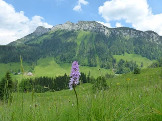
Magnificent is the view to the torn rock bands of the Trogenhorn. On a good forest path, you return to the Fallbach and through a very swampy hollow to Fall. The little valley through which the pass path passes by the Grünenbergli hut becomes increasingly narrow. Over open pastures and through loose forest, the rough path winds in a zigzag up to the Grünenberg pass. At the rest area, you enjoy a magnificent view into the forested Eriz and to the Honegg. The extensive Seefeld-Hohgant nature reserve, which here stretches as a narrow band over the height, delights all nature lovers with its limestone cliffs, karst fields, high moor ponds, rare grasses, and flowers. The rural living culture also finds a distinctive boundary at Grünenberg pass: The farmhouses in Eriz unmistakably show the Emmental style of construction. Under the high hipped roof, living quarters, stable, and barn are combined. The Habkern house, on the other hand, is a pure residential house with the slightly inclined gable roof usual in the Oberland. Shortly after the rocky passage on the pass height, the path turns southwards and becomes a mountain road. The Oberland mountain giants Finsteraarhorn, Eiger, Mönch, and Jungfrau now show themselves beautifully above the forested ridge of the Harder. With an even slope, it goes down into the Trogenmoos at the edge of the nature reserve and unfortunately still on asphalt to the Säge above the Traubach. A hillside road now leads downstream to the magnificent viewing point on the Farenbühl (post bus route termination) and down into the cozy village of Habkern with its beautiful Oberland houses.
The descent via Bort–Rüti–St. Niklausen–Unterseen to Interlaken West requires an additional hiking time of 2 hours.

Good to know
Pavements
Best to visit
Directions
Innereriz-Grüenenberg Pass-Trogenmoos-Habkern
Equipment
We recommend the following equipment: light trekking shoes, light backpack, sun protection, rain jacket, first aid kit, light picnic, sufficient fluids, mobile phone.
Additional information
Association Bernese Hiking Trails, Bern, Tel.: 031 340 01 01, E-mail: info@beww.ch, Homepage: www.bernerwanderwege.ch
Literature
Hiking book Pass routes of the Bernese hiking trails
License (master data)
Safety guidelines
This route runs exclusively on marked trails in the category hiking path.
Map
Swisstopo hiking map 1:50,000 254T Interlaken
Nearby