Experience a lot – hike briefly


- 1:20 h
- 5.60 km
- 2 m
- 1 m
- 558 m
- 560 m
- 2 m
- Start: Thun, station
- Destination: Gwatt, Moos bus stop
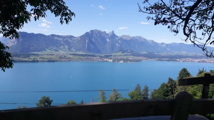
At the signpost at Thun station, the destination of the hike, Gwatt, is already indicated. At first, the route follows the landing stage towards Lake Thun. After a short distance, you reach the former Scherzligen station site via a wooden footbridge. From 1861 (the opening of the railway line to Spiez) until 1893, Scherzligen was the terminus of the line from Bern. For travelers and goods, onward travel was by steamship. Panels explain the 'Scherzligen transport stories'. A little further on appears the Scherzligen church, built from the 10th to 12th century. It is popular for wedding services. For pilgrims on the Einsiedeln-Geneva Jacob's Way, it is an important stage. Immediately after, you reach Schadau Park with the castle of the same name (built in 1846). In the park is the Wocher Panorama, a circular painting of Thun from 1814. On the lake side, you have a view of the triad Eiger, Mönch, and Jungfrau. Exiting Schadau Park, walk a few meters along Seestrasse. Then turn left onto the newly created lakeside path. A little later, it joins Rougemontweg. Once again, a short section along Seestrasse follows. Then you pass by the shipyard, the beach bath (called Strämu by the Thun residents), and Lachen stadium into Pfaffenbühlweg. The beach path now leads close to the shore and on a footbridge on the lake to Bonstetten Park. The gardens, established in the 18th century as part of the country estate, are a popular recreational area for young and old. Along Gwattlischemoos, you head to the end of the route, the bus stop Gwatt, Moos.

Good to know
Pavements
Best to visit
Directions
Thun - Schadau - Bonstetten Park – Gwatt
Equipment
We recommend the following equipment: Light trekking shoes, light backpack, sun protection, rain jacket, first aid kit, light picnic, sufficient fluids, mobile phone.
Directions & Parking facilities
Outbound: By train to Thun
Return: By bus from Gwatt Moos to Thun or Spiez and further by train
Additional information
Association Bernese Hiking Trails, Bern, Tel.: 031 340 01 01, E-mail: info@beww.ch, Website: www.bernerwanderwege.ch
Literature
Hiking book Short Hikes 2 of the Bernese Hiking Trails
License (master data)
Safety guidelines
This route runs exclusively on signposted paths of the hiking trail category.
Map
Swisstopo hiking map 253 T Gantrisch 1:50,000
Nearby