Col du Pillon - Key to the Diablerets area


- 4:00 h
- 12.60 km
- 600 m
- 650 m
- 1,155 m
- 1,546 m
- 391 m
- Start: Gsteig
- Destination: Les Diablerets
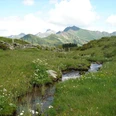
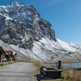
The white crane and the golden battlement tower in the coat of arms of Gsteig indicate on the one hand the former affiliation to the territory of the Greyerz (crane), and on the other hand an old Roman fort on the Sanetschweg (castle). The French place name Châtelet (originally Chastalet) also mentions this defensive or refuge tower. However, there is no feeling of defense either side of the language border, as the Upper Valais dialect is spoken there as fluently as French. The inn «Bären» in the center of Gsteig was built in 1756. With its elaborately decorated front, carved wood, paintings, and inscriptions, it is considered one of the most beautiful houses in Saanenland. A visit to the church dedicated to Saint Theodul from 1453 should not be missed. Along the Rüschbach, a path leads uphill, crosses the pass road, and follows the rushing mountain stream to Alp Ägerte. After a short intermediate ascent, it continues easily with slight ups and downs to the extensive Alp Reusch. On a soft path, descend to the bridge, hold your course and ascend again through the forest at the valley station of the Reusch-Oldenegg railway. Over the clearing of Alp Felix, the path steeply ascends to Alp Les Ertets. Wonderful backward views to the peaks of the Saanenland mountains and ahead to the pass height. This is overshadowed by Gemskopf adorned with cable car masts. On a soft grassy path, it goes over the canton border to the pass road and on the old pass road to the nearby Col du Pillon with a mighty cable car system (Glacier 3000 with summer and winter skiing operation). From the pass height, briefly follow the beaten path next to the road until the footpath branches off to the left, which falls into the pasture basin of Creux du Pillon. Below the imposing Cascade du Dar, the wild run of the mountain stream is followed along the wooded Gorge du Dar on a rough, occasionally slippery but well-equipped path with boardwalks. The change in vegetation from spruce forest to birch forest is striking. Through floodplain forest, you reach the forest road at La Corba, which leads along the rushing Grande Eau directly into the center of Les Diablerets. The massive rock bands on the northern slope of the Diablerets group tower mightily into the sky.

Good to know
Pavements
Best to visit
Directions
Gsteig - Reusch - Col du Pillon - Gorge du Dar - Les Diablerets
Equipment
We recommend the following equipment: light trekking shoes, light backpack, sun protection, rain jacket, pocket first aid kit, light picnic, sufficient fluids, mobile phone.
Directions & Parking facilities
Outbound trip: by train to Gstaad. Then by bus to Gsteig, Post
Return trip: by train or bus from Les Diablerets
Additional information
Association Berner Wanderwege, Bern, Tel.: 031 340 01 01, E-Mail: info@beww.ch, Homepage: www.bernerwanderwege.ch
Literature
Hiking suggestion from the hiking book Pass routes in the Bernese Oberland
License (master data)
Safety guidelines
This route runs entirely on hiking trails.
Map
Swisstopo hiking map 1:50,000 263T Wildstrubel
Nearby