Bühlberg - Simmenfälle / In the hiking paradise Simmental


- 2:45 h
- 8.62 km
- 182 m
- 820 m
- 1,103 m
- 1,659 m
- 556 m
- Start: Lenk, Bühlberg
- Destination: Lenk, Simmenfälle
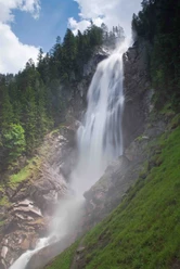
At the starting point of the hike, at the Bühlberg bus stop, you should first follow the direction sign to Metsch. The signpost also shows the destination Simmenfall, but this route runs via the Metschhore. A road passes two chairlift stations to Metschmaad. The view here is impressive. Now follow the hiking trail towards Metsch. After a few minutes you reach an alpine path. Here you should follow the mountain hiking trail towards Nessli. The path leads through forest to Loueneweidli. A rest area is offered here. The roar of the Simmenfälle can already be heard. It continues first level over an alpine pasture, then through forest. After crossing the Bummerebach, the path rises steeply. Leaving the forest, you hike over an alpine path to the Nessli mountain hut. Now the descent begins, now the sign says Simmenfall. Mostly on alpine roads, sometimes on a path, you reach Stalde. From here the route is again marked as hiking trail. At the Barbara bridge, the view of the mighty Simmenfälle is worthwhile. Continuing downhill, the tour leads to the Simmenfälle bus stop and to the restaurant of the same name.

Good to know
Pavements
Best to visit
Directions
Equipment
Directions & Parking facilities
Outbound: By train via Spiez – Zweisimmen and by bus further to Lenk Bühlberg
Return: By bus from Lenk Simmenfälle to Lenk and further by train via Zweisimmen - Spiez
Additional information
Literature
Short hikes hiking book 2 of the Bern Hiking Trails
License (master data)
Safety guidelines
This route runs entirely or partially on marked trails of the mountain hiking path category.
Map
Swisstopo hiking map 263T Wildstrubel 1:50'000 or hiking map from Lenk-Simmental Tourism
Nearby
